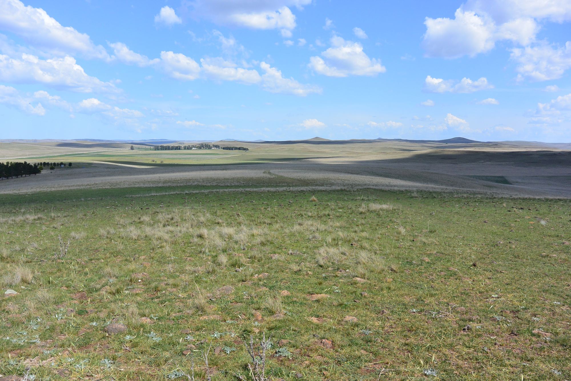
Open, gently undulating grazing country on the Monaro high plains at Rock Flat, with cleared paddocks extending to a distant ridgeline under a wide sky.

Rock Flat, New South Wales, Australia  |  between Sydney, Canberra and Melbourne

Rock Flat Data Centre, AI & Energy Precinct

A potential Digital Infrastructure & Energy Precinct: 50 to 300 MW of staged data centre development being investigated on up to 837.7 hectares (about 2,070 acres) near Cooma, in south-eastern Australia.

The infrastructure is the opportunity. The convergence is the differentiator. Feasibility is the next step.

Go straight to the plan Open the interactive plan Every lot and line, the Cooma district, satellite imagery, and the photographs taken at each one.
837.7ha
Up to, across 11 lots. About 2,070 acres. Developable footprint to be established
50to300MW
Scale being investigated, in stages. Not confirmed capacity
132+66kV
Electricity lines crossing the holding. Capacity untested
Gas
Eastern Gas Pipeline crossing the holding, confirmed present by its owner. Capacity untested
Fibre
Telstra optical fibre marked at the boundary. Capacity and diversity to establish
~900m
Elevation and a cool climate, which may support low water cooling. No supply demonstrated
10km
To Cooma, none of it within 4 km. Canberra 126 km; Sydney 406 km; Melbourne 630 km
Wind
Regional wind already exports on the 132 kV line. No supply committed to this site
The infrastructure convergence

Most sites have some of the ingredients. Rock Flat potentially brings almost all of them together.

Next-generation data centres need more than land and a nearby line. They need energy, new generation, storage, network resilience, fibre diversity, a water solution, transport access, physical separation, room to expand and a community that benefits. What is unusual here is how many of those sit within or beside one holding.

Ten ingredients around one holdingThe 837.7 hectare holding at the centre. Around it: 132 kV and 66 kV lines, the Eastern Gas Pipeline, Telstra fibre, the Monaro Highway, a cool climate and separation from town, all present; on-site solar and storage, and a local workforce and services, as opportunities; community benefit, to be designed. Regional wind at Boco Rock already exports on the 132 kV line, with no supply committed to this site.One holding837.7 haup to, across 11 lots132 kV + 66 kVcross Lot 1 · capacity untestedEastern Gas Pipelinepresent, confirmed by JemenaTelstra fibremarked at the boundaryMonaro HighwayState road, 3.9 km through itCool climateabout 900 m · 19.4 °C mean maxSeparation, not isolationCooma 10 km, none within 4 kmCommunity benefitto be designed togetherOn-site solar + BESSroom to investigateLocal workforcepotential access, Cooma 10 kmRegional windoperating · exports on 97R todayBoco Rock wind, 114 MW, alreadyexports north to Cooma on this line.No supply is committed to this site.
What exists
  • Up to 837.7 ha across 11 lots, as supplied
  • 132 kV and 66 kV lines crossing Lot 1
  • The Eastern Gas Pipeline, confirmed present by Jemena
  • Telstra optical fibre marked at the boundary
  • The Monaro Highway, a State road, through the holding
  • A cool climate at about 900 m
  • Cooma 10 km away, none of it within 4 km
  • Regional wind already exporting on the 132 kV line
What could be developed
  • Data centre campuses, in stages
  • On-site solar and battery storage
  • Additional electrical infrastructure
  • Diverse fibre routes
  • A dedicated low-water cooling solution
  • Gas-supported resilience and firming
  • A host-community benefit model
What must be proven
  • Grid capacity and the connection pathway
  • Gas pressure, offtake and terms
  • Fibre capacity and route diversity
  • The water solution
  • The planning pathway
  • The developable footprint
  • The energy architecture, costs and commercial feasibility
The proposition

There is enough here to justify serious feasibility. Not one perfect attribute, but an unusually broad combination of land, electricity infrastructure, renewable energy opportunity, gas, fibre, transport access, cool climate, separation and community-development potential in one location.

Some of these are verified physical attributes. Some are identified infrastructure. Some are development opportunities. Some remain to be proven. The distinctions are kept throughout this site, and the FAQ sets out which is which.

For readers outside Australia

See where it is in Australia
Australia · New South WalesSnowy Monaro Regional Council area, in the south-east of the country
Country and state
36.28° S, 149.16° EInland from the Tasman Sea coast, on the Monaro high plains
Coordinates
78, 252 and 391 milesBy road to Canberra, Sydney and Melbourne: 126, 406 and 630 km. Cooma is 6 miles
Distances in miles
2,070 acres · 2,950 ftUp to 837.7 ha, at about 900 m. Annual mean maximum 18.2 to 19.4 °C, about 65 to 67 °F
In imperial units
AEST, UTC+10UTC+11 during daylight saving, from early October to early April
Time zone
National Electricity Market50 Hz, New South Wales region. Local distribution by Essential Energy
Electricity grid
Canberra and SydneyCanberra Airport carries scheduled passenger services and international freight, with no curfew. Sydney is the country’s largest international airport
International gateways
Sydney, Canberra, MelbourneAWS, Microsoft Azure and Google Cloud all publish cloud regions in Sydney and Melbourne, and Microsoft also in Canberra. Sydney is the main east-coast landing for international subsea cables
Cloud and subsea context

Position is not performance: no latency, carrier route, capacity or service to any of these places is claimed, and carrier diversity remains a gating question on the Connectivity page. Conversions are rounded from the metric figures used across this site. Road distances as on the interactive plan. Cloud regions as published by AWS, Microsoft and Google; cable landings from the TeleGeography Submarine Cable Map. Links open in a new tab.

Why Rock Flat

Ten reasons, in three themes

Each states the evidence, then what it does not yet establish. The full account of each is on its own page.

Energy

01  Existing high-voltage infrastructure

132 kV and 66 kV cross the holding

Essential Energy’s 132 kV feeder 97R and a 66 kV line cross Lot 1, the 132 kV on poles built for two circuits with one strung. An unusually strong starting point for connection feasibility. It is not capacity: no rating or available capacity is published for 97R, and a 114 MW wind generator already exports on it. Power →

02  Access to regional renewable energy

Wind already runs on the line

Wind generation operates in the district and exports on the same feeder, and the locality is a candidate Renewable Energy Zone. A future operator could investigate the power purchase agreements the NSW Guidelines now require. No generator has committed supply to this site. Energy →

03  On-site solar opportunity

Room to masterplan compute and generation together

Up to 837.7 hectares, about 642 of them clear of the three energy corridors, gives scope to investigate utility-scale solar beside the compute load. The solar footprint and its output are feasibility items. Energy →

04  Battery energy storage

A battery planned in from the outset

The Guidelines expect storage and demand flexibility from a campus of this kind. Land here allows a battery to be designed in for firming, peak management, flexibility, grid support and resilience. Its size follows the engineering, and none is stated. Energy →

05  Gas infrastructure and firming

The Eastern Gas Pipeline crosses the holding

Jemena’s pipeline crosses Lot 1 and is marked on the ground by Jemena. That creates an opportunity to investigate gas-supported resilience, emergency generation and firming, not a baseload gas proposition. Pressure, offtake, connection and terms are Jemena’s to answer. Energy →

The physical site

06  Exceptional scale

Up to 837.7 hectares, designed together

The value of the holding is not its size but what its size allows to be designed together: data halls in stages, a second campus, substations, solar, storage, cooling and water infrastructure, setbacks, buffers, construction compounds and expansion, without competing for space. The developable footprint is still to be established. The site →

07  Cool-climate advantage

About 900 m, with a 19.4 °C mean maximum

The Monaro climate may support cooling architectures that use less energy and less water than warmer markets need. Which architecture, and its performance, are engineering questions; no efficiency figure is claimed. The site →

08  Separation without isolation

Close enough to Cooma, apart from it

Cooma, about 6,700 people, is 10 km away by the Monaro Highway, and nothing of the town lies within 4 km. That offers potential access to a regional workforce, contractors and services alongside physical separation from dense residential development. Scattered rural dwellings remain sensitive receivers to be mapped. The district, to scale →

Connectivity and access

09  Fibre infrastructure

Telstra fibre marked at the boundary

Telstra’s own markers place an optical fibre cable on the holding’s fence line and NBN Co identifies an asset. Capacity, dark fibre, carrier options, diverse routes, entry points and latency are all for telecommunications feasibility to establish. Connectivity →

10  Monaro Highway access

A State road through the holding

A road managed by Transport for NSW runs 3.9 km through the holding: the route for transformers, modular components, construction traffic, workforce and maintenance. Heavy-vehicle access to the gate is not yet confirmed. Access →

A different model

A precinct designed to bring its infrastructure with it

One of the largest problems facing very large data centre developments is their effect on the electricity, water and community infrastructure already there.

Transgrid advised in August 2026 that capacity to connect to the transmission network in the Sydney basin is largely exhausted. Inserting a very large new load into a constrained metropolitan network is the proposition many sites are now forced to make.

Rock Flat’s scale and infrastructure characteristics create the opportunity to investigate a different one: a precinct that adds generation, storage and infrastructure alongside its demand. None of it is committed, and each item is a feasibility question. The point is that the land and the corridors make each one possible to ask.

A future development could potentially incorporate
  • Additional renewable generation
  • Battery storage
  • New electrical infrastructure
  • A resilient energy supply
  • A dedicated low-water solution
  • New telecommunications capacity
  • Road and access improvements
  • Community investment
Energy architecture

Build the energy system with the data centre

The next generation of large-scale digital infrastructure cannot be considered apart from the energy system that supports it. Rock Flat offers the opportunity to investigate an integrated architecture from the outset.

A potential architecture, subject to feasibility, not committed infrastructure. The proposition is not that electricity is available here. It is that the compute load and its supporting energy ecosystem can be designed together. The energy page sets out each pathway →

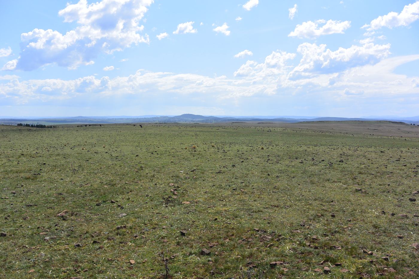
Wide open cleared grazing land at Rock Flat extending to low hills on the horizon, illustrating the scale and gentle topography of the property.
The opportunity

More than a landholding

This should be viewed as an infrastructure precinct rather than simply a land sale.

Data centre developers typically need to assemble land, power, connectivity, access, security buffers and expansion capacity. At Rock Flat, several of those ingredients potentially converge in one location.

Up to 837.7 hectares, across the eleven lots as supplied, provides the flexibility to investigate a staged campus incorporating data centres, substations, energy generation, BESS, renewable infrastructure and substantial future expansion.

Potential applications include

  • Hyperscale cloud infrastructure
  • AI and GPU computing campuses
  • High-performance computing
  • Colocation
  • Sovereign or government infrastructure
  • Energy-intensive digital infrastructure
  • Integrated data centre and energy development
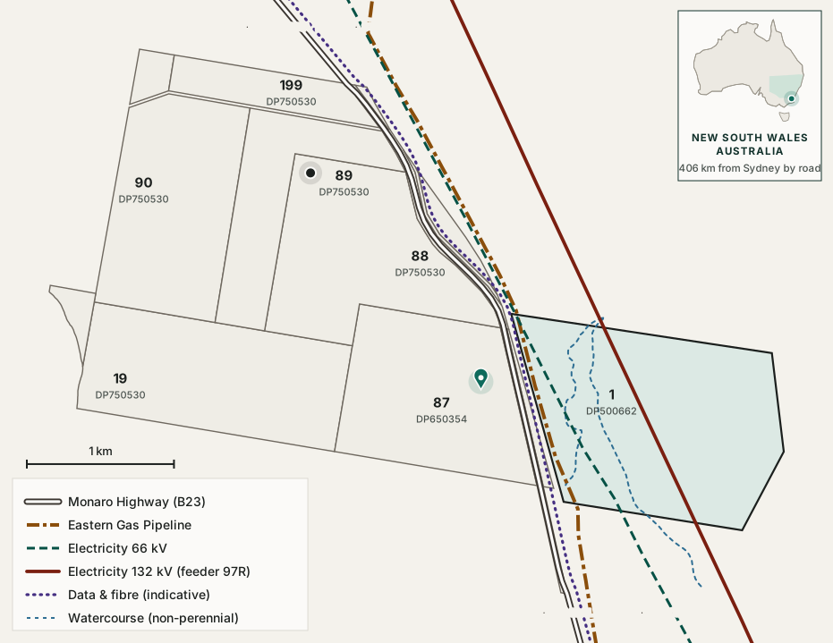
Scaled plan of the holding showing eleven cadastral lots, with the Eastern Gas Pipeline, a 66 kV line, a 132 kV line and two watercourses all crossing the shaded eastern lot, and the Monaro Highway running through the holding. The interactive plan: every lot, the gas pipeline, both electricity lines and fibre

The holding as supplied, with the three energy corridors that cross it, gas, 66 kV and 132 kV, and the highway and indicative fibre corridor through the middle. Indicative only, not a survey; boundaries are subject to survey and title confirmation.

Indicative visualisation only

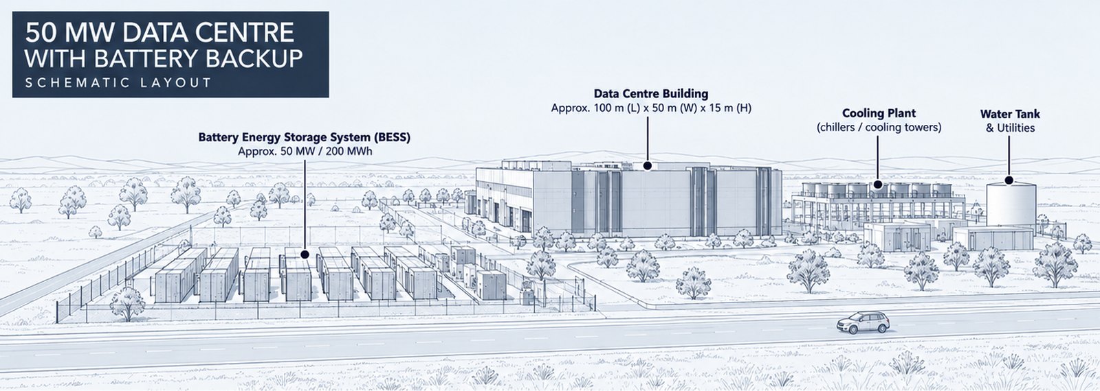
What a 50 MW first stage could look like

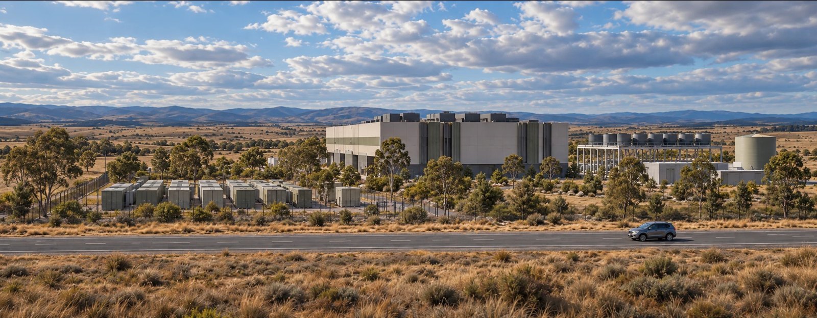
Photorealistic visualisation of a 50 megawatt data centre on open Monaro grazing land beside the highway: a long low data hall, a fenced battery energy storage yard of container units in the foreground, cooling plant and a water tank to the right, with ranges on the horizon.
Schematic line drawing of the same 50 megawatt layout: data centre building of about 100 by 50 metres, a battery energy storage yard of about 50 megawatts and 200 megawatt hours, cooling plant and a water tank, set back from the highway.
Schematic layout, not to scale. The same first stage as a line drawing: data centre building, battery energy storage, cooling plant and a water tank, all set back from the highway within the holding.

Indicative visualisation only, 50 MW first stage with battery storage. An artist’s impression of what a first stage could look like from the Monaro Highway: a data hall of roughly 100 m by 50 m, a battery yard drawn at the size the Guidelines’ storage rules would imply for a 50 MW stage, cooling plant and a water tank. Three things to read with care. The building is drawn at about 15 m; the current control on this land is 9 m, so height is itself a planning matter. The battery is drawn as a policy envelope, not an engineered size. And the cooling plant is generic: the design base case is closed loop or hybrid cooling, not evaporative towers. Nothing shown exists, is approved, or represents a committed layout or capacity.

Why now

The question has changed

The question is increasingly not simply where the next 100 MW of compute can be built. It is where the compute, energy, water and community infrastructure can be designed together.

Rock Flat is presented as a location worth assessing in detail against that question, not as an answer to it.

The trends converging
  • Rapid growth in AI and high-performance computing
  • Rising Australian data centre demand
  • More power required per campus
  • Growing grid constraints, with Sydney basin capacity largely exhausted
  • Expectations of additional generation and storage
  • Closer scrutiny of water use
  • Stronger expectations of community benefit
  • Demand for very large sites
  • Resilient energy architectures
NSW Data Centre Guidelines, August 2026

Designed for the new generation of NSW data centres

The NSW Government's August 2026 Data Centre Guidelines fundamentally change the criteria for successful large scale data centre development.

Future projects are expected not only to secure electricity, land, water and fibre, but to help create new renewable generation, energy storage and water infrastructure, minimise impacts on communities and support regional economic development. Rock Flat offers the foundations for exactly this model.

The opportunity combines a regional location, substantial development potential, proximity to electricity, gas and telecommunications infrastructure, land with room to investigate renewable generation and battery storage, and the potential to develop an integrated 50 MW to 300 MW data centre and energy precinct.

An initial screening against the seventeen performance measures is on the NSW Guidelines page, with its limits stated: it is the proponent’s own judgement, not a compliance rating, and no policy requirement has been identified that appears inherently incompatible with the site. Most measures need engineering, utility agreements and a defined design before they can be demonstrated.

The critical next step is therefore not further high level site identification. It is a targeted technical feasibility program to quantify grid capacity, fibre diversity, water strategy and energy precinct configuration, and to determine the optimal first stage of development.

Victoria has moved the same way

On 22 September 2026 the Victorian Government released its Sustainable Data Centre Action Plan. It requires new data centres to bring “their own renewable energy supply and storage” to “match new demand with new generation”, to “meet connection costs and network upgrades”, to use “recycled or non-drinking water for cooling”, to stay out of residential zones with a 150 metre buffer from homes, to train and hire locally, and to deliver a “Local Investment Guarantee” to the host community. Victorian rules do not apply to a New South Wales project. They matter here as evidence that Australian data centre policy, in the two largest states, now expects compute, new generation, water and community benefit to be designed together. Source: Premier of Victoria, 22 September 2026 (opens in a new tab)

What the Guidelines now favour

  • Regional locations outside the Sydney Ring
  • Available land and existing infrastructure
  • Additional renewable generation, 40% wind
  • Large scale battery storage
  • Grid flexibility: 25% of load for two hours
  • Low water cooling solutions
  • Distance from dense residential areas
  • Regional jobs, training and local supply chains
Evidence at a glance

What has been confirmed, and what has not

Four asset owners responded to a Before You Dig Australia enquiry on 26 August 2026, a site inspection followed on 27 August, and a second inspection on 5 and 6 September photographed the fibre, gas and electricity assets marked on the holding by their owners. This is the current position, stated without embellishment.

AttributeStatusBasisDetail
High pressure gasConfirmedJemena confirms the site could impact its high pressure Eastern Gas Pipeline. Pipeline Section: EGP Midline.Energy
132 kV at the siteConfirmedAsset plates identify Essential Energy feeder 97R, Cooma to Bega, on double-circuit-capable poles with the second circuit vacant.Power
Carrier fibreConfirmedTelstra’s own warning post on the boundary reads “optical fibre cable in this vicinity”, with numbered route markers along the fence. Capacity and a second route are not established.Connectivity
Highway accessConfirmedMonaro Highway B23, classified State road HW19 managed by Transport for NSW, runs 3.9 km through the holding.Access
Land and expansionStrong evidenceUp to 837.7 ha of predominantly open grazing land across 11 lots as supplied, with direct Monaro Highway frontage.The site
Climate for coolingStrong evidenceCooma annual mean maximum of 18.2 to 19.4 °C at about 850 to 900 m elevation.The site
Firm grid capacityGating itemNo rating or utilisation is published for feeder 97R, and a 114 MW wind generator already exports on it.Power
Planning permissibilityGating itemRU1 Primary Production is not a prescribed zone for data centres. A planning pathway is required.Planning
Water supplyGating itemNo large scale supply has been demonstrated. Now ranked ahead of gas in feasibility priority; a closed loop, low water or hybrid cooling design is the base case.The site
No capacity is claimed

Nothing on this website should be read as secured power, contracted gas, connected fibre, an available megawatt figure or a planning approval. The value of the site at this stage lies in how many of the difficult-to-create fundamentals are already present, not in how many questions have been answered. The executive summary sets out every figure with its source.

What happens next

The opportunity is compelling. The next stage is validation.

Four gating questions decide whether this site proceeds, with gas a valuable fifth and planning running alongside. Each is a low-cost enquiry relative to the value of the answer, and each should be scoped against the 50, 100, 200 and 300 MW stages.

01  Power · critical Essential Energy, feeder 97R Can the network provide an economically viable initial 50 to 100 MW connection, expandable towards 300 MW? Preliminary and detailed connection enquiry quoting asset CE 253562. The workstream with the longest tail. 02  Fibre · critical Telstra plus a second carrier Can two carrier-diverse, high capacity fibre connections with acceptable latency be obtained? A formal carrier and fibre feasibility report, not a location plan. 03  Water · critical Cooling and rainfall-independent supply Can an acceptable low water or rainfall-independent cooling solution be demonstrated? Closed loop, low water or hybrid cooling is the base case, and the water source, capacity and utility position follow from it. 04  Energy precinct · critical Solar, storage and grid flexibility Can the land and network architecture accommodate solar, BESS, a wind PPA and the 25% for two hours of grid flexibility the Guidelines require? A dispatch architecture and layout at each stage. 05  Gas · high Jemena Eastern Gas Pipeline At what pressure, flow rate and connection cost could the pipeline support 25, 50, 100 MW or greater generation? Dispatchable firming and resilience, not a substitute for the renewable commitment. 06  Planning · alongside Specialist NSW planner Lot-by-lot zoning confirmation, permissibility advice, rezoning versus State Significant Development strategy, net developable area, and the pre-lodgement service of the NSW Department of Planning, Housing and Infrastructure (DPHI).

The detailed position

A pre-feasibility executive summary sets out the site specification, the asset owner responses in full, the staged capacity proposition, the gas and cooling arithmetic, the planning pathway and the four workstreams, distinguishing throughout what has been evidenced from what has not. It includes an appendix recording the infrastructure identified on site and an appendix recording the position against all seventeen NSW Data Centre Guidelines performance measures.

Frequently asked questions

What it could mean for the region, and what is yet to be determined

The community questions come first. Rock Flat is at the opportunity and feasibility stage. The infrastructure identified at and around the property creates a compelling basis for further investigation, but key capacities and development pathways remain subject to technical, commercial and regulatory assessment.

What could a project of this scale mean for Cooma and the Snowy Monaro region?

Potentially, a long-term employer and purchaser in a region whose economy already includes a large energy operator, a substantial visitor economy and agriculture. The areas it could touch are employment, skills, procurement, community energy, community infrastructure and digital connectivity. What it will mean depends on what a partner commits to and what the community asks for, and neither is known. No figures for jobs or economic contribution are stated on this site.

Read the full answer →

Which regional community projects have stalled, and could a precinct help?

Several have been publicly reported: the Cooma and Bombala pools, closed since works began in June 2025; the Monaro Rail Trail, funded for only a short section near Bombala; the cancelled arts and innovation centre in Bombala’s former infants school; and a 2024 proposal to stop maintaining some low-traffic roads. A precinct could be asked whether it would support some of them, through a voluntary planning agreement or a community fund, if one proceeds. Which projects, and how much, would be for the council and the community to decide. Nothing has been offered or priced.

Read the full answer →

What types of jobs could be created, and could local people and businesses take part?

Construction roles across civil, electrical, mechanical, telecommunications and transport trades, spread over the years a staged build would take, then permanent operational roles. Local contractors could be reached through a local-procurement approach with early notice of work packages, and training could be explored with TAFE NSW, schools and universities. How many roles, and how many could be filled locally, are for a partner’s workforce plan. No figure is stated.

Read the full answer →

Would a precinct pay for anything before it is approved?

No. Contributions of this kind follow a project that is approved and proceeds, and they are secured through the planning process, a voluntary planning agreement or a partner’s own commitments. Rock Flat has no approval and no partner yet, and no contribution, fund or project has been offered, agreed or priced. Describing the possibilities now lets the community say what it wants before a feasibility program is designed, not after.

Read the full answer →

How large is the Rock Flat landholding?

Approximately 837.7 hectares across eleven lots as supplied, about 2,070 acres, which provides substantial space to investigate data centre campuses, energy infrastructure, solar generation, battery storage, substations, buffers, access and future expansion. The figure is the total of the lot polygons, not a title area, and it includes 17.9 hectares of highway road reserve. The developable footprint for each use remains subject to detailed site, environmental, planning and engineering assessment.

How much electricity is available at Rock Flat?

No figure is stated, because none has been established. The property has identified 132 kV and 66 kV electricity infrastructure crossing the landholding, which is an important starting point for connection investigations. Available capacity, connection configuration, augmentation, timing and cost must be established with Essential Energy and Transgrid. The 50 to 300 MW proposition describes the scale of data centre opportunity being investigated. It does not represent confirmed grid capacity.

Is Rock Flat connected to gas?

The Eastern Gas Pipeline crosses the property, and Jemena, its owner, has confirmed it is there. That creates an opportunity to investigate gas-supported resilience, firming or other future energy applications. Pipeline proximity does not establish connection availability, pressure, capacity, cost or commercial terms. Those require investigation with Jemena and technical advisers. There is no connection today.

Is fibre available?

Telstra optical fibre infrastructure has been identified at the property boundary, marked by Telstra’s own posts, and NBN Co has identified an asset in the area. Available capacity, dark fibre availability, latency, carrier diversity, physically diverse routes and redundant entry points remain matters for telecommunications feasibility. None of them has been established.

Could renewable energy be developed at the site?

The scale of the landholding creates an opportunity to investigate on-site solar and battery energy storage, alongside potential procurement of renewable electricity from regional generation. Wind generation already operates in the district and exports on the 132 kV line that crosses the holding, but no generator has committed supply to this site. No solar, battery or renewable generation capacity is stated until engineering and commercial assessment support one.

What is the proposed size of the data centre?

Rock Flat is being investigated as a potential location for approximately 50 to 300 MW of data centre development, potentially delivered in stages, and potentially as more than one campus. This describes the scale of opportunity under investigation. It is not a statement of confirmed electrical capacity or of development approval.

What about water?

Water and cooling strategy will form an important part of feasibility. Rock Flat’s cool climate may support cooling approaches designed to minimise water consumption. The aspiration is to investigate solutions that avoid routine reliance on potable town water for cooling, including air cooling, closed-loop systems, hybrid systems and non-potable sources such as captured rainwater or recycled water. No water supply or cooling solution has been secured.

What happens next?

Detailed technical and commercial feasibility with experienced infrastructure and development partners. It should investigate grid capacity and connection, renewable generation, storage, telecommunications, gas, water and cooling, planning, environmental constraints, staging, infrastructure costs, commercial structures and a community benefit framework.

Have a more detailed question? Explore the full FAQ →  ·  Community questions →

Commercial flexibility

Multiple ways to participate

A long-term ground lease is the preferred structure, and acquisition is the second preference. The opportunity could also be structured in a number of other ways, depending on the counterparty and the stage at which they wish to engage.

Preferred structure

Long-term ground lease

Land retained, campus developed by others.

The starting point for discussion. The landholding stays with its owner, and a developer or operator takes a long-term lease over the land it needs to build and run the campus, staged as the precinct grows.

  • Land retained by the owner
  • Campus developed and operated by others
  • Area, term and staging open for discussion
Discuss a ground lease
Second preference

Acquisition

Outright purchase of the landholding.

For a party that would rather own the land than lease it. The lots, the area and the terms are open for discussion.

  • Outright ownership of the land
  • Title, lot schedule and cadastral detail available to qualified parties
Discuss an acquisition
Also open to
  • 03Option agreementA secured position while diligence is completed
  • 04Development partnershipShared development of the precinct
  • 05Joint ventureAligned participation in the outcome
  • 06Land contributionLand contributed into a larger infrastructure development

Commercial terms are open for discussion with qualified parties.

Next step

Move from opportunity to feasibility

Rock Flat is seeking engagement with experienced digital infrastructure, energy and investment partners to undertake the next stage of technical and commercial feasibility. Detailed title, infrastructure, utility and commercial information is available to qualified parties.

  • Achievable data centre capacity
  • Grid connection pathway
  • Renewable energy strategy
  • Solar and BESS opportunity
  • Gas resilience options
  • Telecommunications capacity and diversity
  • Cooling and water strategy
  • Planning pathway
  • Staging
  • Infrastructure costs
  • Commercial delivery model
  • Community benefit framework