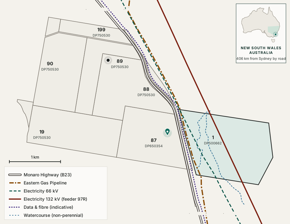
A holding in southern New South Wales, Australia: eleven cadastral lots as supplied, with the gas pipeline, the 66 kV and 132 kV electricity lines, an indicative data and fibre corridor and the mapped watercourses drawn to scale. Switch layers on and off, select anything to see what it is and why it matters to the offer, or step out to where it is in Australia.
Drawn from NSW MinView vector exports of 27 August 2026 and the supplied lot plan. Indicative only, and not a survey. Boundaries, areas and asset positions must be confirmed against title and against the asset owners.
Drag to pan, scroll to zoom, or use the buttons. Select any lot or line for detail, on the plan or by name in the layer list. Everything is also reachable by keyboard, and from the schedule below.
Select a lot or a line on the plan, or a name in the layer list.
Photographs
On the ground
Select a lot or a line on the plan and the photographs of it appear here.
What the plan shows
The key facts, as they appear on the plan
The plan is the evidence for most of the key facts at the top of this page, and it is drawn to scale. Read in the same order, this is what it shows for each, and what it does not.
1 Land837.7 haUp to, across the 11 lots as supplied. About 819.8 ha once the highway reserve, Lot 7101, is set aside.
2 Scale642 haClear of all three energy corridors: every lot except Lot 1. This is where data halls, solar and storage for a 50 to 300 MW pathway can go.
3 Electricity2 lines1,467 m of 132 kV and 1,516 m of 66 kV, both inside Lot 1 DP500662 and no other lot.
4 Gas1,348 mOf the Eastern Gas Pipeline inside Lot 1, beside the two electricity lines: three energy corridors in one 195.3 ha lot.
5 Data and connectivity3.9 kmOf highway reserve through the holding, the likely fibre corridor. Drawn dotted because it is indicative: no route plan has been supplied.
6 Water2 channelsMapped non-perennial watercourses, both in Lot 1. A riparian constraint, not a supply: the water case rests on low water cooling.
7 Location10 kmTo Cooma on the highway that runs through the holding, and nothing of the town within 4 km. The same road reaches Canberra in 126 km; Sydney is 406 km and Melbourne 630 km. ·
8 PolicyRegional, with roomWhat the August 2026 NSW Guidelines favour is visible here: a regional site, land for generation and storage, and distance from dense housing. NSW Guidelines →
Three energy corridors in one lot: read it both ways
Gas, 66 kV and 132 kV all cross Lot 1 DP500662 and no other lot. The fourth line on the plan, data and fibre, is indicative and follows the highway reserve through the middle of the holding. The first of those facts cuts in both directions.
Read as an advantage
Three energy services converge in one place, which is why the site is worth investigating at all. A connection to gas, to 66 kV or to 132 kV is a short run from the same corner of the property, and the corridors are already there, so no new easement across open country is needed to reach them.
Read as a constraint
Every easement, setback and riparian restriction lands on the same 195 hectares. The developable area of Lot 1 is materially less than its title area, and quantifying that reduction is one of the more valuable pieces of early work available. The other 642 hectares, clear of all three, are where buildings can go.
Access and distances
The site fronts the Monaro Highway, route B23, which Transport for NSW classifies as State road HW19 and manages and funds for its full 205 km New South Wales length. That matters more than it sounds: the heaviest single items in a data centre build arrive as oversize and overmass loads, and a State highway is a materially simpler approval path than a council road.
Road distances and typical driving times from the site
Destination
By road
Typical drive
Route
Cooma
10 km
9 min
Monaro Highway B23. Regional centre, workforce and services
Canberra, the national capital
126 km
1 h 30
Monaro Highway B23 the whole way
Canberra Airport
~125 km
1 h 30
Scheduled passenger and international freight, no curfew
Sydney
~406 km
4 h 30
Monaro Highway, Federal Highway and Hume Motorway M31
Melbourne
~630 km
7 h 45
Monaro and Princes highways via Cann River
Bega and the far south coast
~119 km
1 h 30
Snowy Mountains Highway B72 over Brown Mountain
Port of Eden
~173 km
2 h 20
Via Bega, then Princes Highway A1
Jindabyne
~68 km
50 min
Snowy Mountains region
Bombala
~95 km
1 h 05
Monaro Highway B23 south
Nimmitabel
~44 km
30 min
Monaro Highway B23 south
All road distances are measured from the site at 7845 Monaro Highway, rounded. One kilometre is about 0.62 miles: Canberra is about 78 miles, Sydney about 252 and Melbourne about 391. Drive times are typical for a car in normal conditions; a heavy or oversize vehicle will take longer. Sources: Transport for NSW schedule of classified roads; routing distances cross-checked between two independent providers.
What the highway gives the project
A State road managed by Transport for NSW (TfNSW) to the boundary, 10 km from a regional centre and 126 km from Canberra on the same highway. Canberra Airport carries scheduled passenger services and international freight and has no curfew. Both the Australian Capital Territory (ACT) and New South Wales governments are currently upgrading this corridor: a $260.5 million ACT programme explicitly aimed at freight efficiency for southern New South Wales, and a TfNSW safety and efficiency programme that includes works between Rock Flat and Nimmitabel.
What still has to be checked
Heavy vehicle access has not been confirmed to the gate. A Snowy 2.0 transport plan records the Monaro Highway as generally an approved 25 to 26 metre B-double route apart from a section inside Cooma, and whether that affects a northbound movement from Rock Flat needs checking on the National Heavy Vehicle Regulator network map. Road train access has not been established. Site access geometry onto a classified road requires Transport for NSW agreement, and the property report records a 1.5 m classified road buffer.
Two things not to claim
Cooma has an airport but no scheduled flights. Cooma–Snowy Mountains Airport, about 15 km from town, has a sealed 2,120 m runway and handles aeromedical and general aviation, but its own website states that no airlines currently fly there. It is an asset worth noting for charter and aeromedical access, not a passenger connection.
Government hosting rules do not require proximity to Canberra. The Australian Government Hosting Certification Framework governs ownership and control of hosting providers, not their geography. Canberra's pull is commercial and latency-driven, not regulatory, and the argument for a site near it should be made on that basis.
Lot schedule, as supplied
Lots as supplied, with area and whether the mapped energy corridors, gas, 66 kV and 132 kV, cross them
Lot
Area
What the plan shows on it
195.3 ha
All three energy corridors, gas, 66 kV and 132 kV, and both watercourses
130.5 ha
Clear of the energy corridors
127.5 ha
Clear of the energy corridors
124.8 ha
Clear of the energy corridors. Holds the site pin, and adjoins Lot 1
122.3 ha
Clear of the energy corridors
67.9 ha
Clear of the energy corridors. Holds the registered address point
34.4 ha
Clear of the energy corridors
17.9 ha
The Monaro Highway reserve, and the indicative data and fibre corridor along it. Clear of the energy corridors
7.8 ha
Clear of the energy corridors
7.0 ha
Clear of the energy corridors
2.3 ha
Clear of the energy corridors
Total, 11 lots as supplied
837.7 ha
Diligence item: which parcels form the holding
The 837.7 ha across 11 lots used across this site is the total of the lots
as supplied on this plan, which is why the area is stated as up to that
figure rather than as a settled number. It is not a title or survey area.
Two deductions to expect. Lot 7101 measures 3.9 km long at an average width of
about 52 m, which makes it the Monaro Highway road reserve rather than a paddock,
and road reserve is not usually part of a freehold sale. Removing it leaves 819.8 ha
across the ten remaining supplied lots. Easements, riparian setbacks and the corridors on this plan will
reduce the developable footprint further again. A consolidated title, easement and area schedule is the
first item of the title work, and the reconciliation is recorded in the executive summary.
Sources: supplied cadastral lot plan and infrastructure corridor plan, both drawn from NSW MinView vector exports of 27 August 2026; Before You Dig Australia Job 54074165 (Essential Energy, Jemena, Telstra, NBN Co); site inspection of 27 August 2026 for the 132 kV asset plate; Essential Energy Distribution Annual Planning Report 2025. Corridor lengths within Lot 1 and nearest-approach distances are as given on the supplied plans. This page is indicative and is not a survey, a title search or a service location.
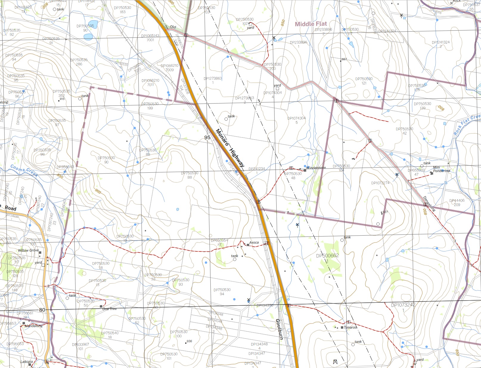
The interactive plan above is built from cadastral and infrastructure data supplied for this holding. The New South Wales topographic series maps the same ground from an entirely separate source. Where the two agree, the reading is stronger; where the topographic map adds something, it is set out below.
Two transmission lines, both crossing Lot 1 DP500662. They are drawn as parallel dash-dot lines running north-north-west to south-south-east, in the same position as the 66 kV and 132 kV corridors on the plan above. That plan and this map do not share a source, so this is a second, independent record of the same two lines. The topographic series does not label voltages, so it corroborates their position and not their rating.
Elevation, from contours rather than a point reading. Index contours at 850 m and 900 m run across the holding, with spot heights of 887, 915, 927 and 936 m on the surrounding country. The roughly 900 m figure used elsewhere on this site sits inside that range.
Gentle gradient. At a 10 metre contour interval, the spacing across the paddocks is wide. Widely spaced contours mean a shallow slope, which is what governs earthworks, building platforms and the cost of a large flat pad. This is the clearest evidence of terrain the site has, short of a survey.
The watercourses and the highway alignment both match the plan above, and the property is named on the map, which is a useful cross-check on the parcel identification.
What it adds
Farm water tanks, dam points and wind pumps across the holding; sparse tree cover shown as light green; the neighbouring homesteads; and the cattle grids and gates on the highway frontage. None of these are in the supplied data.
What it does not establish
A topographic map is not a survey and not a capacity record. It shows no underground assets, so the Eastern Gas Pipeline does not appear on it and its absence means nothing. A 10 metre contour interval cannot resolve local grading, drainage falls or a building platform. Nothing here changes the two gating items, which remain firm electricity capacity and carrier diversity.
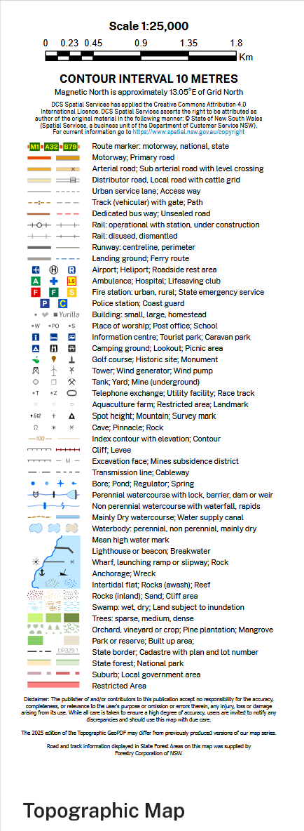
The sheet legend. Reproduced so every symbol on the extract can be read without the full map. The transmission line symbol, the 10 metre contour interval and the cadastre style are the three that matter most here.
Next step
Move from opportunity to feasibility
Rock Flat is seeking engagement with experienced digital infrastructure, energy and investment partners to undertake the next stage of technical and commercial feasibility. Detailed title, infrastructure, utility and commercial information is available to qualified parties.